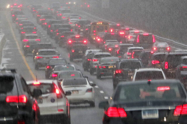
The Western Pennsylvania region can expect about an inch or two of accumulated snow from an incoming trough of lower pressure this afternoon, according to the National Weather Service in Pittsburgh.
Meteorologist Myranda Fullerton said the region should expect possible snow bands starting this afternoon about 1 and lasting until about 10 p.m. Banded snow showers are capable of reducing visibility to three miles or less, and could mean a rapid accumulation along roadways, she said.
“This would present an evening commute type of concern,” Fullerton said. “If you’re along I-80 or I-79 for example, these heavier bands, they can cause rapid deterioration in conditions. Drivers could have very good visibility and then all of the sudden their visibility becomes very reduced.”
The Winter Weather Advisory has been expanded to include the Laurel Highlands. Otherwise, snow showers continue through eve. Few localized heavier snow bands possible this PM. This could cause a rapid reduction in visibility & quick accumulation of snow on roads/hazardous travel. pic.twitter.com/wuiyjq6Lgu
— NWS Pittsburgh (@NWSPittsburgh) January 26, 2023
Fullerton said it isn’t predicted to get much warmer than the current freezing temperatures, which will lead to snow accumulations. She emphasized the importance of practicing safe driving when experiencing lower visibility.
“We normally ask that people just slow down, make sure that they give themselves enough distance between them and the car in front of them,” Fullerton said. “We also suggest that drivers turn on their low beam headlights in a situation where you start to experience a rapid decrease in visibility.”
The new snow will help bring the region closer to par with what it usually gets. To date, the Pittsburgh area has received almost 10 inches less than the average amount of snow predicted for this year.
According to Fullerton, despite having a lower snowfall this winter, the precipitation levels have remained normal, presenting as rain rather than snow. She said that snow bands can form based on a region’s local conditions.
“We get lake enhancements from Lake Erie and the surrounding Great Lakes, and it’s the Great Lakes area in particular that makes this region more prone to these types of banding and potential snow bands,” Fullerton said.
The Climate Prediction Center released an eight- to 14-day temperature outlook that shows a cold start to February with lower-than-average temperatures, and “above normal” precipitation chances.